IBCSO (bathymetric chart)

IBCSO2 logo square padded web

The International Bathymetric Chart of the Southern Ocean Project (IBCSO) aims to produce the authoritative map of the Southern Ocean and South Pacific, South Atlantic, and South Indian Ocean south of 50°S. It is a regional undersea mapping project of the General Bathymetric Chart of the Ocean (GEBCO). GEBCO again is under the auspice of the International Hydrographic Organization (IHO) and the Intergovernmental Oceanographic Commission (IOC) of UNESCO. Since 2017, IBCSO is also part of the Nippon Foundation – GEBCO Seabed 2030 Project.

About

IBCSO v2 web

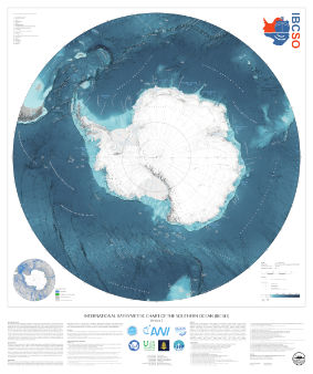
The International Bathymetric Chart of the Southern Ocean (IBCSO) Project aims to produce the authoritative seafloor map for the Southern Ocean and South Pacific, South Atlantic and South Indian Ocean south of 50°S. As regional mapping project of the General Bathymetric Chart of the Oceans (GEBCO) and the Nippon Foundation – GEBCO Seabed 2030 Project (Seabed 2030), IBCSO has the ambitious goal to map the seafloor south of 50°S by 2030 entirely.

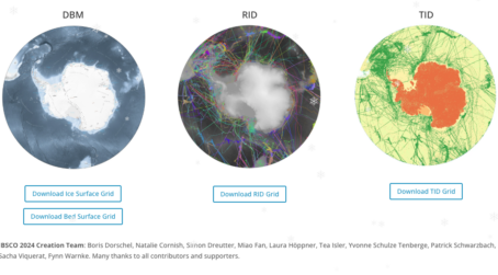
In June 2022, the second version of IBCSO (IBCSO v2) was published by Dorschel et al. in Scientific Data revealing the seafloor in this area in so-far unprecedented detail. It is by far the most comprehensive compilation of bathymetric data for the area. As the largest repository of bathymetry data from the Southern Ocean, IBCSO v2 is also the definitive source for scientists, cartographers, and others looking for a map of the seafloor. You can find IBCSO v2 DBMs in GEO-TIFF and NetCDF format as geographic data and in IBCSO-projection as well as an RGB grid and a digital chart for unrestricted download at https://doi.org/10.1594/PANGAEA.937574. The DBMs have a resolution of 500 m × 500 m, stretch from 50°S to the South Pole, and are available as ice-surface topography and sub-ice topography. For more information, please also see Dorschel et al. (2023).

Within SCAR, IBCSO is an Expert Group under the GeoSciences Group. It is hosted by the Alfred-Wegener-Institut Helmholtz-Zentrum für Polar- und Meeresforschung in Bremerhaven, Germany and part of GEBCO and the Nippon Foundation – GEBCO Seabed 2030. It however represents a truly global effort with support and data contributions from institutes, institutions, companies, and individuals from all over the world that share the common interest in Antarctica and the Southern Ocean.

In order to make the vision of IBCSO and Seabed 2030 of a fully mapped ocean a reality, we would like to encourage everybody who has bathymetric data to share these data with the IBCSO project. If you feel that you can contribute, please contact us at ibcso@awi.de. We will continuously work to make IBCSO v3 an even more amazing map.

Dorschel B., Hehemann L., Viquerat S., Warnke F., Dreutter S., Schulze Tenberge Y., Accettella D., An L., Barrios F., Bazhenova E., Black J., Bohoyo F., Davey C., De Santis L., Escutia Dotti C., Fremand A.C., Fretwell P.T., Gales J.A., Gao J., Gasperini L., Greenbaum J.S., Jencks J.H., Hogan K., Hong J.K., Jakobsson M., Jensen L., Kool J., Larin S., Larter R.D., Leitchenkov G., Loubrieu B., Mackay K., Mayer L., Millan R., Morlighem M., Navidad F., Nitsche F.O., Nogi Y., Pertuisot C., Post A.L., Pritchard H.D., Purser A., Rebesco M., Rignot E., Roberts J.L., Rovere M., Ryzhov I., Sauli C., Schmitt T., Silvano A., Smith J., Snaith H., Tate A.J., Tinto K.J., Vandenbossche P., Weatherall P., Wintersteller P., Yang C., Zhang T., Arndt J.E., 2022. The International Bathymetric Chart of the Southern Ocean Version 2. Scientific Data 9, 275, https://doi.org/10.1038/s41597-022-01366-7.

For continued improvements to IBCSO, we need your input. If you have data and you are happy share these, or if you want to give feedback and suggestions, please get in contact or visit us at ibcso.org.

News and Research Updates from the Southern Ocean Bathymetry Community.

Members

Contact

For further information on the IBCSO group, please email southern-ocean[at]seabed2030.org.

Southern Ocean Regional Center Team

Our center team is involved with, not only the production of IBCSO, but also in developing best methods for infrastructure and innovation, establishing a sense of community and facilitating collaboration, and in acquiring bathymetric datasets in uncharted waters.

Boris Dorschel web Boris Dorschel is the project lead as head of the bathymetry working group in the geophysics department at AWI. Since 2012, he credits his time to the geo-morphology of the seafloor in high latitudes with special emphasis on the reconstruction of ice sheet histories and habitat mapping. As part of his activities, he collects multibeam echosounder data from around Antarctica and the Arctic. With his expertise and passion for running highly-collaborative projects at a global level, he is keen to lead bathymetric mapping expeditions and expand the impact for the IBCSO.
Laura Hehemann web Laura Hehemann is the data manager and curator for the project responsible for building a robust and sustainable hub. She collaborates with key bathymetry stakeholders in the shared Seabed 2030 vision to map the world’s oceans. She joined AWI in 2016 as a geographic information systems (GIS) analyst engaging scientists in web-based services and providing GIS expertise. After various research expeditions to the Arctic, working with optical and acoustical data from the Ocean Floor Observation and Bathymetry System (OFOBS) and the ships multibeam echosounder, she made her first voyage to the Antarctic in 2019.
Sacha Viquerat web Sacha Viquerat is our chief data engineer for the project. With a background in biological sciences, mainly marine mammals, and scientific programming and statistics, he joined the team primarily to re-implement the data processing pipeline and scale the existing workflow onto AWI’s high-performance infrastructure. He made his first trip to Antarctica in 2014 and has since participated and contributed in various national and international projects. His work in Seabed 2030 involves heavy usage of the Python programming language for parallel computation and geographic libraries in a UNIX environment and coined our SEAHORSE workflow.
Simon Dreutter web Simon Dreutter is the data manager of the bathymetry working group at AWI, providing data and insight into the bathymetry archive. He has several years of ocean-going experience and a main research interest in high-resolution multisensor habitat mapping in deep sea environments. He oversaw the technical integration of the acoustical systems into the OFOBS platform and regularly trains students for bathymetry acquisition. As a skilled cartographer, passionate programmer and inspiring educator, he brings a diverse perspective and high quality to the project.
Fynn Warnke web Fynn Warnke has participated in several research cruises worldwide (Antarctica, Baffin Sea, southern Indian Ocean) and two industry cruises (North Sea, Baltic Sea). He joined the team as a talented and passionate data engineer bringing expertise in bathymetric mapping and innovation to working with big data. He is highly trained in scientific computing, namely Python, Matlab, and motivated to implement new techniques and approaches to advance the project.
Yvonne Schulze Tenberge web Yvonne Schulze Tenberge supports the IBCSO team with her knowledge of PostgreSQL databases and programming skills. She has a background in environmental engineering and fluvial geomorphology. Since 2020, she works as a data engineer for the AWI Bathymetry group in the project mareHub with focus on data visualization.
Patrick Schwarzbach web Patrick Schwarzbach, semi-professional photographer, web designer and private teacher, supports Seabed 2030 by increasing outreach on various platforms for the Southern Ocean Regional Center. Furthermore, he helps to enhance data analysis as a multidisciplinary trained scientist. He first came in touch with marine sciences working from 2018 to 2020 at the German Oceanographic Museum in Stralsund and looks forward to his first Antarctic expedition.
Jan Erik Arndt web Jan Erik Arndt was the co-chair of the IBCSO project from 2010 until 2021, and the co-lead until 2021. In 2013, he completed the first version of IBCSO, which has gained tremendous popularity since. He established the initial workflows and the network, laying the foundation of IBCSO as we have it today.

Regional Mapping Committee

The Southern Ocean Regional Mapping Committee (SO-RMC) is overseen by an Editorial Board and was updated during the First Arctic, Antarctic and North Pacific Mapping Meeting held in Stockholm, October 8-10, 2018 to currently include the following members:

Felipe Barrios Servicio Hidrografico y Oceanografico de la Armada (SHOA) Chile
Jenny Black Institute of Geological and Nuclear Sciences (GNS) New Zealand
Fernando Bohoyo Instituto Geologico y Minero de Espana (IGME) Spain
Harald Brekke Norwegian Petroleum Directorate (NPD) Norway
Miquel Canals University of Barcelona (UB) Spain
Jongkuk Hong Korean Polar Research Institute (KOPRI) Korea
Martin Jakobsson University of Stockholm (SU) Sweden
Johnathan Kool Australian Antarctic Division (AAD) Australia
Robert D. Larter British Antarctic Survey (BAS) UK
German Leitchenkov The All-Russia Scientific Research Institute for Geology and Mineral Resources of the Ocean (VNIIOkeangeologia) Russia
Hugo Montoro Direccion de Hidrografía y Navegacion de la Marina de Guerra del Peru (DHN) Peru
Frank O. Nitsche Lamont-Doherty Earth Observatory (LDEO) USA
Yoshifumi Nogi National Institute of Polar Research (NIPR) Japan
Michele Rebesco Istituto Nazionale di Oceanografia e di Geofisica Sperimentale (INOGS) Italy
Walter Reynoso-Peralta Servicia Hydrographica Naval (SHN) Argentina
Jodie Smith Geoscience Australia (GA) Australia

If you have substantial interest in the Southern Ocean bathymetry please visit the IBCSO website.

Resources

Publications, Data and Links of interest to the Southern Ocean Bathymetry Community

Publications
Data
Links