A new GNSS coordinate time series covering 286 sites across Antarctica and the sub-Antarctic from 1995 to 2021 has been released by the SCAR-endorsed GIANT-REGAIN project (Geodynamics In ANTarctica based on REprocessing GNSS dAta Initiative). By consolidating data from more than 20 institutions and networks, the project has addressed challenges related to fragmented data access, inconsistent metadata, and varied processing methods. The resulting data set provides a consistent and carefully validated record of bedrock movement, intended to support investigations of geodynamic processes such as glacial isostatic adjustment (GIA), plate motion, and post-seismic deformation. The initiative contributes to SCAR’s ongoing efforts to enhance geodetic infrastructure in Antarctica and to provide data that underpin research on ice mass balance and sea level change.
The data set, developed through collaboration between four analysis centres, offers improved spatial and temporal coverage compared to previous compilations and is freely available to the scientific community. It provides an important resource for validating GIA models, improving estimates of Antarctic mass balance, and guiding future geodetic deployments.
Abstract
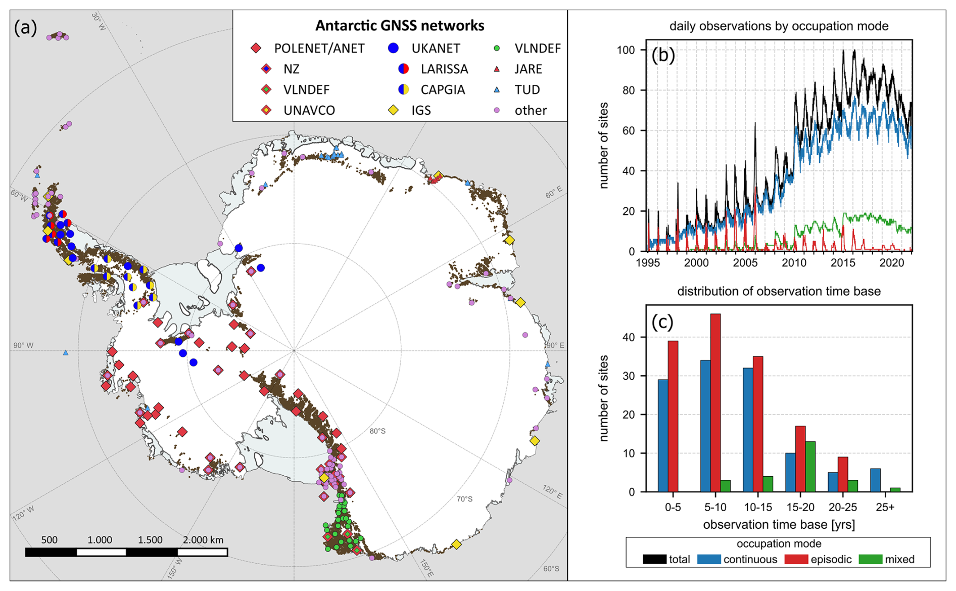
For nearly 3 decades, geodetic Global Navigation Satellite System (GNSS) measurements in Antarctica have provided direct observations of bedrock displacement, which is linked to various geodynamic processes, including plate motion, post-seismic deformation, and glacial isostatic adjustment (GIA). Previous geodynamic studies in Antarctica, especially those pertaining to GIA, have been constrained by the limited availability of GNSS data. This is due to the fact that GNSS data are collected by a wide range of institutions and network operators, with the raw observational data either not publicly available or scattered across various repositories. Further, the metadata necessary for rigorous data processing have often not been available or reliable. Consequently, the potential of GNSS observations for geodynamic studies in Antarctica has not been fully exploited yet. Here, we present consistently processed coordinate time series for GNSS sites in Antarctica and the sub-Antarctic region for the time span from 1995 to 2021. The data set is composed of 286 continuous and episodic sites, with 258 sites having a time span longer than 3 years. The coordinate time series were obtained from a combination of four independent processing solutions using different GNSS software and products, allowing the identification of inconsistencies in individual solutions. From these, we infer a reliable and robust combined solution. A key issue was the thorough reassessment of station metadata to minimise artefacts and biases in the coordinate time series. The resulting data set provides coordinate time series with unprecedented spatiotemporal coverage, promising significant advancements in future geodynamic studies in Antarctica.
The data set is freely available at https://doi.org/10.1594/PANGAEA.967515 (Buchta et al., 2024a).
How to cite: Buchta, E., Scheinert, M., King, M. A., Wilson, T., Koulali, A., Clarke, P. J., Gómez, D., Kendrick, E., Knöfel, C., and Busch, P.: Advancing geodynamic research in Antarctica: reprocessing GNSS data to infer consistent coordinate time series (GIANT-REGAIN), Earth Syst. Sci. Data, 17, 1761–1780, https://doi.org/10.5194/essd-17-1761-2025, 202
Read the full article: https://doi.org/10.5194/essd-17-1761-2025